
University News
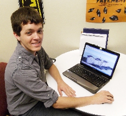
Dane Severinsen (Germantown Hills, IL), a Western Illinois University senior majoring in instructional design and technology, used Google's free 3D modeling software, Google Sketchup, to create three-dimensional models of buildings located on WIU's Macomb campus and submit them to Google Earth. Currently, 10 3D models (of building on the WIU-Macomb campus) are viewable, and he has three more awaiting release.
[Download Print-Quality Image]
![[Download Print-Quality Image]](http://www.wiu.edu/images/news/10861/10861_3240_1.jpg)
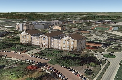
Screenshot of the WIU-Macomb campus on Google Earth by Dane Severinsen, who created all the three-dimensional models on campus using Google Sketchup, Google's free 3D modeling software. Severinsen is a senior majoring in instructional design and technology.
[Download Print-Quality Image]
![[Download Print-Quality Image]](http://www.wiu.edu/images/news/10861/10861_3241_1.jpg)
WIU IDT Student Puts WIU Campus on Google Map… 3D Style
June 20, 2013
MACOMB, IL — If you've perused the map of Western Illinois University on Google Earth, you may have noticed a few of the buildings appear to be three dimensional or "in 3D." Sherman Hall, the Leslie F. Malpass Library, Waggoner Hall and a few other buildings protrude from a mostly otherwise flat depiction of the campus. So far, 10 buildings on the WIU-Macomb campus are available for viewing this way, all thanks to the hands of Dane Severinsen (Germantown Hills, IL), a senior majoring in instructional design and technology, who used Google's free 3D modeling software, Google Sketchup, to create the models.
The website for the free Sketchup program encourages individuals to "join the worldwide geo-modeling community, and help put every village, town, and city on the 3D map." According to Google, an individual's 3D models can appear in Google Earth and Google Maps (see sketchup.google.com/yourworldin3d). Although Severinsen said he was able to use the 3D modeling software and the project for an independent study-course in Spring 2013, he started creating 3D renderings of the WIU Macomb campus buildings as a personal, independent endeavor last September because the opportunity presented itself.
"I first became interested when I was using Google Earth, and I realized no one else had done it yet, which was a little surprising to me. There wasn't a single building on the campus that was modeled, so I saw it as an opportunity to leave my mark on campus," Severinsen explained. "I think it's really cool that anyone can access it and see the three-dimensional appearance of the buildings. I think it can be especially good for international students, who can't necessarily come and visit in person, but they can come and visit virtually."
He noted that he first became interested in using Google Earth, and the possibilities it offers for three-dimensional projects, a few years ago.
"I think it was in 2005 or 2006, when they came up with the three-dimensional buildings. When it was first released, the 3D buildings looked like gray blobs… not too pretty. But as the technology progressed, it enabled users to create buildings that could look more lifelike. That's when I started to really become interested in three-dimensional modeling, to try to bring the maps to life," he said.
According to Severinsen, creating each three-dimensional building model tends to be a tedious, painstaking process. To start, he takes a number of photographs of the building he plans to model.
"I take photos of the front, back and all around it, to get a good perspective so I can make the model look as accurate as I possibly can. I even go as far as counting every brick on the building to know how high it is," he said. "The amount of time it takes to complete each rendering depends on the size of the structure and how intricate it is. A simple building can take four hours, while a really complex one can take 25-30 hours."
After he completes a building rendering, he then has to upload and submit each file to Google for an approval-and-release process. The first part of Google's relatively simple process works much like any other web-based program to which you upload an image or graphic file.
"All you have to do is key in what you want to call the building (I always use the proper name of each building, and you can also put in a description, such as URL to WIU's website), then you just click on an 'upload' button to upload the Google Sketchup file," he explained. "Before a new rendering is viewable on Google Earth, it goes through a two-step process. It first needs to be accepted manually at Google—they make sure it follows the guidelines for models, and if it does, it gets approved. The second step involves when the model will be released and available to view on Google Earth. Google establishes release dates for their 3D models, so once a model is approved, you may not necessarily see it right away. It will be available for viewing the next time Google decides to release the newly added 3D models. The whole process can take anywhere from a week to a month."
At this point, Severinsen has 10 3D building models available for viewing via Google Earth, including: Currens Hall, Horrabin Hall, Knoblauch Hall, the Malpass Library, Morgan Hall, the Multicultural Center, Sallee Hall, Sherman Hall, Stipes Hall and Waggoner Hall. He has three buildings awaiting release by Google Earth, including Memorial Hall, Western Hall/the Donald S. Spencer Student Recreation Center (which are connected) and Mowbray Hall. While he said he plans to continue to work on rendering the buildings on campus, he would more than welcome anyone else creating and adding 3D models of WIU-Macomb campus buildings.
"I would like to see other people get interested in doing this, so it's not just me doing it. What I have found is that some universities in the country have teams of five, six or even seven people creating 3D model for campus buildings. So far for Western, it's just been me."
For more information, contact Severinsen at DK-Severinsen@wiu.edu. Learn more about WIU's Department of Instructional Design and Technology at www.wiu.edu/idt.
Posted By: Teresa Koltzenburg (WIUNews@wiu.edu)
Office of University Communications & Marketing
Connect with us: