
University News
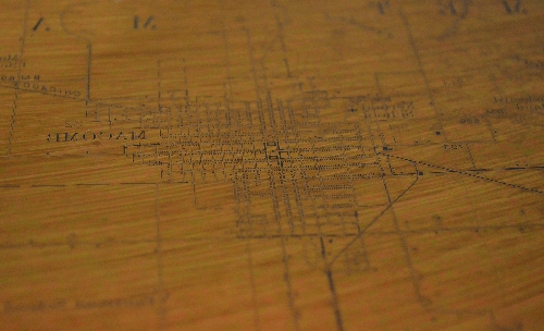
This photo is a close up of a copper printing plate that was formerly owned by the U.S. Geological Survey and used in the early 20th century to make maps of the Macomb area. It was acquired by Western Illinois University Libraries through the Federal Surplus Property program, with help from the Illinois State Agency for Surplus Property, and funding from an anonymous donor. Delicate details, such as roads and place names, are visible on the surface of the plate (pictured in reverse) as well as a chemical sheen left over from the transfer process.
[Download Print-Quality Image]
![[Download Print-Quality Image]](http://www.wiu.edu/images/news/12186/12186_4158_1.jpg)
Copper Printing Plate Used to Make Historic Local Maps Now at WIU's Malpass Library
December 18, 2014
MACOMB, IL — Western Illinois residents and Western Illinois University students, faculty and staff members can view a copper printing plate used in the early 20th century to make local maps. According to University Libraries Marketing and Outreach Librarian Christina Norton, the archives and special collections unit at WIU Libraries' Leslie F. Malpass Library is now the home of the plate, which was used by the U.S. Geological Survey (USGS).
"The plate was acquired on behalf of University Libraries after this plate and others like it were 'surplused' by the USGS—meaning because they are no longer in use, educational and other organizations can request them for their collections," WIU Government and Data Services Librarian Linda Zellmer explained. "These copper plates were used by the USGS to print almost all of their maps from the time of USGS's founding in 1879 until the 1940s, when copper plates were phased out in favor of faster methods."
The plate was acquired through the Federal Surplus Property process, with the assistance of the Illinois State Agency for Surplus Property, as well as funding from an anonymous donor, Norton added.
Zellmer, with the assistance of Mary Day (from University Libraries' administration office), worked to acquire the plate. According to Norton, Day processed the paperwork to establish WIU as an eligible Federal Surplus recipient.
"The plate we acquired shows the cultural features, such as roads and place names, on the Macomb quadrangle, which was published as part of the Colchester-Macomb folio in 1919. The plate was based on original survey work done in 1912," Zellmer noted.
Maps made from the plate are viewable in person on the sixth floor of the Malpass Library or online at http://pubs.er.usgs.gov/publication/gf208.
According to Zellmer, the printing process, using these plates, was an intricate undertaking.
"From books and resources that describe the process, I have learned that they were hand-engraved in reverse (backwards) and then checked for errors. Once a plate was deemed correct, the engraving was transferred to a lithographic stone using a complex multistep process," she said. "The plate still contains chemical residues left over from this technique. We hope to have the plate cleaned so it can be placed on permanent display with the maps in the archives and special collections unit."
University Libraries Archivist Jeff Hancks added faculty and staff at University Libraries are pleased with the acquisition of the plate.
"In this digital era, we believe students and regional residents will find it fascinating to discover how maps were made at the turn of the last century," he said. "We encourage people to come to the archives to see this plate and other fascinating maps we have in our collection."
For more information, contact the University Archives at (309) 298-2717 or via email at Malpass-Archives@wiu.edu.
Posted By: University Communications (U-Communications@wiu.edu)
Office of University Communications & Marketing
Connect with us: