
Earth, Atmospheric, and Geographic Information Sciences News
Journey to Korea through Maps: The National Atlas of Korea
During the 2023 Geography Awareness week, Dr. Jongnam Choi (EAGIS) and Dr. Amy Mossman (English) introduced the 3rd Edition of the National Atlas of Korea (4 volumes). After the short presentation, traditional Korean snacks were introduced, along with popular Korean snacks and beverages that can be seen in Korean dramas and movies.
WIU Students Leading the Way for Conversion to Next Generation 911
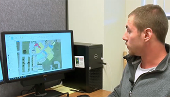
The Department of Earth, Atmospheric, and Geographic Information Sciences is proud of its GIS Center and students’ involvement in updating extensive county level mapping databases to align with Illinois’ Next Generation 911 systems. Read the full story on WGEM.com.

A Professor's Love of Trains
January 26, 2022: Dr. Sunita George, Associate Professor of Geography, gave a commentary to Tri-States Public Radio on her perspective about her love of trains.
I love trains. When I first moved to Macomb, more than a few people warned me about the “noisy trains” that woke them up at ungodly hours, and cautioned me about planning for delays because of active railway crossings. All I thought was, BONUS! I have a life-long infatuation with trains; I overlook their faults, I forgive them their tardiness, I believe in them. When disgruntled freight train drivers hoot the horn incessantly at 4:00 AM, if I hear it at all, it is like a strange lullaby to me. And like all love stories, sometimes they drive me mad, but it is always a story with a happy ending. Read the full story on tspr.org.

WIU's GIS Center, School of LEJA Provide Hands-On Training, Learning Opportunities
June 16, 2021: Recently, a hands-on (drone) sUAS Flight Operations Course was held on the WIU-Macomb campus, where participants learned how to fly drones to perform emergency response operations, such as search and rescue, using scenario-based training. In addition, two virtual drone-related classes were held during the spring semester, which were composed of more than 50 students from WIU, along with area emergency management agencies, police departments, fire departments, the Illinois State Police and the Illinois Emergency Management Agency. Those classes, held in March, focused on the Unmanned Aerial System (UAS) certification by the Federal Aviation Administration (FAA) that is mandatory for practitioners and students to use drones and drone-related technology in any professional operations in the area of public safety from natural disasters, emergencies, to search and rescue. The June 12 hands-on program was the culminating class for the series, which was led by Chad Sperry, director of the WIU GIS Center. Read the full news release.
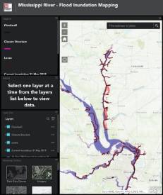
How Technology and WIU's GIS Students Aided Response to the Great Flood of 2019
April 14, 2021: Students gained a tremendous learning experience from these events, with immersion in the use of a wide variety of GIS tools and the need to deliver answers quickly during a crisis. The flood events gave students crucial practice in the fast-paced, high-stakes world of emergency response using GIS—a common and important application of the technology. Read the full story at esri.com.

Meteorology Alumna Featured in Air Force Recruitment Video
November 3, 2020: Kelsi Carney, a 2016 meteorology alum works as an Air Force air traffic controller and has been featured in a military recruiting video. Carney said WIU prepared her for her career by giving her background knowledge in weather, which is a big part of air traffic control work. Read the full story and watch the recruiting video.
COVID-19 Dashboard
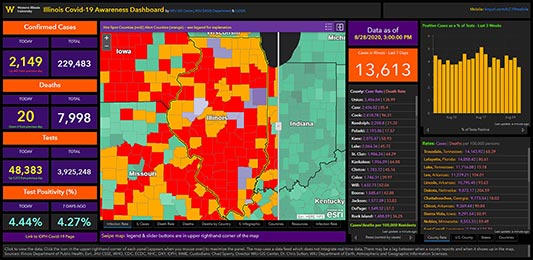
September 23, 2020: As the COVID-19 pandemic continues throughout our state, the nation and the world, two Western Illinois University faculty members continue to refine a map created in mid-March to keep Illinois citizens up-to-date on the numbers of cases, recoveries, deaths and more. The statewide COVID-19 web map and dashboard, launched by the WIU GIS Center, in cooperation with the Department of Earth, Atmospheric and Geographic Information Sciences (EAGIS) and the Illinois GIS Association (ILGISA), is up to 1.3 million views. Read the full news release.
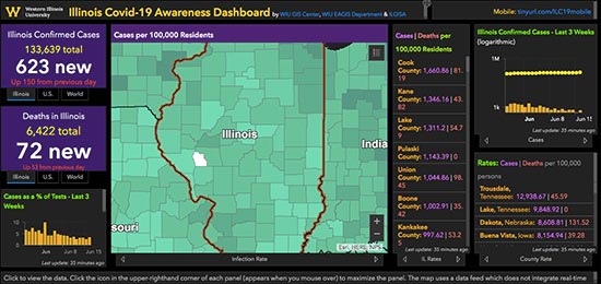
WIU COVID-19 Dashboard & Map Hits 1 Million Views
June 21, 2020: While the state is beginning its abbreviated re-openings of businesses, schools and more across Illinois, the COVID-19 pandemic remains at the forefront and numerous protocols are in place to continue to flatten the curve. To help keep citizens up-to-date with the latest statistics and information, the statewide COVID-19 web map and dashboard launched in mid-March by the Western Illinois University GIS Center, in cooperation with the Department of Earth, Atmospheric and Geographic Information Sciences (EAGIS) and the Illinois GIS Association (ILGISA), continues. And as of today (June 16), the map has had over 1 million views and remains the official public dashboard in Illinois, shared by state and federal agencies, as well as numerous news outlets throughout Illinois. Read the full news release.
WIU EAGIS Department and GIS Center Create Statewide COVID-19 Dashboard to Monitor Reported Cases
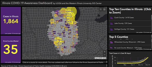
March 26, 2020: The Western Illinois University GIS Center, in cooperation with the Department of Earth, Atmospheric, and Geographic Information Sciences (EAGIS), have assembled a statewide web map to monitor the spread of COVID-19 (coronavirus) in Illinois. Read the full news release.
Connect with WIU: