
WIU Professor Uses Giant Interactive Map to Promote Illinois Geography
April 5, 2017
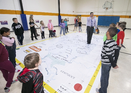
WIU Geography Professor Chris Sutton brought a new, interactive map of Illinois to Lincoln School in Macomb last week to teach third graders about maps.
[Download Print-Quality Image]
![[Download Print-Quality Image]](http://www.wiu.edu/images/news/14426/14426_6441_1.jpg)
MACOMB, IL – When WIU Professor Christopher Sutton delivered his Distinguished Faculty Lecture in Macomb March 22, he had a unique visual to help make his point.
Sutton delivered "The Power of Maps" in Macomb and again this week on WIU's Quad Cities campus. Accompanying him on stage was a 14-foot by 21-foot interactive floor map of Illinois, provided by the Illinois Geographic Alliance. The map is made of a tarp-like material and will be making stops at schools and events around the state.
In addition to using the map for his lecture, Sutton also took the map to Lincoln Elementary in Macomb last week for use by third graders. Sutton said the National Geographic Society produced the large scale maps for each state, as well as developing accompanying lesson plans for third and fourth graders.
"They want to get the maps out to K-12 students and get the kids interacting with it and thinking about geography" said Sutton. "In most places, whole courses on geography don't exist anymore. What better way for kids to experience geography than a big map they can walk around on."
At Lincoln Elementary, the map was set up in the gymnasium for students to interact with. Third grade teacher Linda Poore said the students and teachers all had positive comments about the map.
"Students liked walking on their state, finding rivers and lakes and learning about the grid and locating cities," said Poore. "It was thoroughly enjoyed."
Poore said student comments about the map included "I liked learning about how many states border the Mississippi River" and "It was cool to walk on our state."
Amy Bloom, co-coordinator of the Illinois Geographic Alliance and an instructional assistant professor in the Illinois State University Department of Geography said she was thrilled to have Sutton use the map at Western and in the schools.
"Dr. Sutton is an enthusiastic ambassador for geographic education," said Bloom. "In the coming months, the map will be traveling to other schools and events across Illinois."
Bloom said the overall goal for the traveling map program is "for people of all ages to learn about the geography of Illinois and to increase their overall map skills in an active, engaging, fun and memorable way."
Sutton said his use of the map is a trial run, and now an online system is launching so schools, organizations and communities can request use of the map.
"This is a jumping off point," he said. "We get most of our information visually, so maps are a great way to get kids engaged; it's a pretty powerful thing."
For more information about the map, visit iga.illinoisstate.edu/.
Posted By: Jodi Pospeschil (JK-Pospeschil@wiu.edu)
Office of University Communications & Marketing
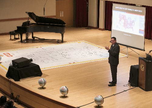
Sutton used the map as part of his Distinguished Faculty Lecture last Monday on the Macomb campus.
[Download Print-Quality Image]
![[Download Print-Quality Image]](http://www.wiu.edu/images/news/14426/14426_6442_1.jpg)
Connect with us: