
New Doppler Radar in Place on WIU's Memorial Hall
August 20, 2019
![[Download Print-Quality Image]](http://www.wiu.edu/images/news/16584/16584_9059_1.jpg)
MACOMB, IL – A new addition to the top of Western Illinois University's Memorial Hall in recent weeks will result in the ability to better predict weather systems approaching the region, as well as added educational opportunities for University students.
The WIU Department of Earth, Atmospheric and Geographic Information Sciences recently purchased a Doppler Radar from the Furuno company. The unit was partially paid for by a trust gift from WIU Professor Emeritus John F. Blauvelt, who taught at Western for 45 years and passed away in 2016, and by donations from McDonough Power Cooperative in Macomb and a group of donors through an online campaign to pay for radar maintenance.
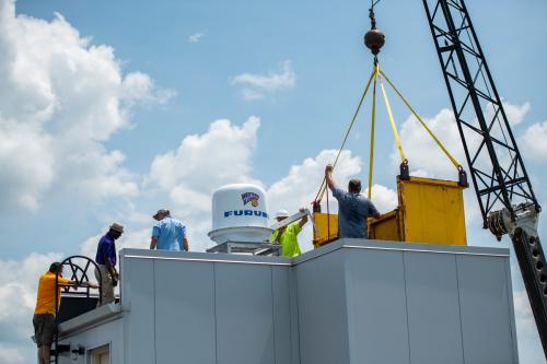
The unit, which has the WIU logo on its outside covering, was raised on to the roof of Memorial Hall two weeks ago by Supreme Radio and placed on its tower. Technicians from Furuno were on campus last week to install and activate the radar and to conduct training sessions on its use. The installation was aided by the campus offices of Facilities Management, University Technology and Central Receiving.
In the coming weeks, the machine will be calibrated and available for use in University classrooms and by the county's Emergency Services and Disaster Agency (ESDA) office.
Prior to the installation, local weather information came from a radar based in the Quad Cities. Because the radar beam had to travel so far, the image was typically only being read from the tops of local clouds. The new radar, which rotates 360 degrees, will read about 70 kilometers, or 45 miles surrounding Macomb.
The new unit will give a much higher resolution radar image and will offer more detailed information to forecasters, including rainfall totals, possible rotation in clouds, hail formation and other weather features.
"This is a total departure from traditional radar images; the resolution is many times clearer," said Gil Passwaters, Furuno project manager. "The data will look totally different from what people are used to."
WIU Meteorology Professor Redina Finch said the higher resolution weather information will allow better storm tracking capabilities.
"We have a graduate student creating a users' guide to the radar for the public so they will know how to use and interpret the data," said Finch.
WIU Associate Professor of Meteorology Marcus Büker said the data produced by the new unit will be invaluable in the University's classrooms.
"We will be able to show through the radar data what's happening on the ground," said Büker. "We will be able to tell, within seconds, when it's going to start raining. This unit has two beams to access how big particles are in two ways, which will allow us to classify precipitation, such as whether it is rain, snow, or hail. This is the first time we will be able to differentiate."
The National Weather Service will have access to the data images produced by the new unit. The new images will also allow for the tracking of bird, bat and insect migrations, and debris plumes from fires. Officials will be able to control the radar from Linux workstations in the Meteorology Lab or from home if interesting weather happens at night when no one is in the office.
Passwaters said the radar allows for the archiving of data, so regional storm systems can be used as examples for academic lessons.
"It allows for storms to be studied later," he said. "The images are very involved and the information the unit can provide can be lifesaving."
The hope is that the images can eventually be linked to a weather app, so live, local radar can be accessed on local residents' mobile devices.
Finch said she envisions the new radar being used by students in meteorology classes, but also in emergency management, law enforcement and justice administration and broadcasting classrooms. Students will also be involved in radar image interpretation and maintaining the website where the radar images will be available.
The department is continuing to raise money for the project to purchase additional software and data storage for the unit.
For more information about the WIU Department of Earth, Atmospheric and Geographic Information Sciences, visit wiu.edu/eagis.
Posted By: Jodi Pospeschil (JK-Pospeschil@wiu.edu)
Office of University Communications & Marketing
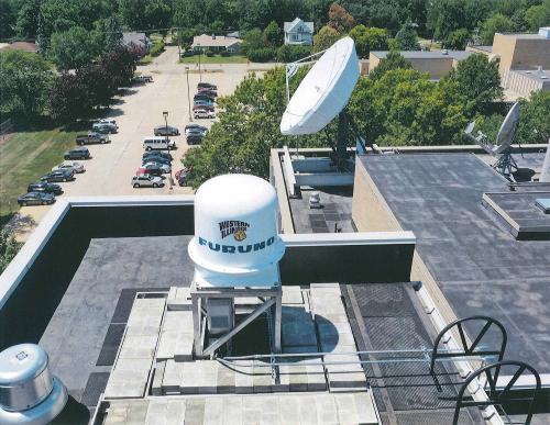
Photo by WIU GIS Center drone
[Download Print-Quality Image]
![[Download Print-Quality Image]](http://www.wiu.edu/images/news/16584/16584_9060_1.jpg)
Connect with us: