
WIU GIS Class Enhances Assessment of Community Needs in Quincy
September 15, 2022
![[Download Print-Quality Image]](http://www.wiu.edu/images/news/18703/18703_11553_1.jpg)
QUINCY, IL – It was a piece of the collective puzzle that tied an Adams County needs study together with a technological bow - students in a Western Illinois University Geographic Information System (GIS) class used the technology they learned in the classroom to bring the final report some user-friendly features.
The United Way of Adams County, directed by former WIU College of Business and Technology Development Director Jeremy Wingerter, completes an assessment of community needs every three years. The most recent assessment began in 2021, and was aided this round by an award from the Restore, Reinvest and Renew (R3) grant, money generated by a tax on cannabis sales in Illinois. The money allowed the Adams County United Way to hire consultant Maggie Strong, owner of Strong Consulting in Quincy, to help compile the report and work with local agencies who were helping with data collection.
Strong happens to be the sister-in-law of WIU Earth, Atmospheric and GIS Professor Chris Sutton. The two began talking about the Adams County project and quickly determined Sutton's GIS students could play a role in the needs assessment.
"This report is a snapshot of their future," said Sutton. "It also shows the social applications of GIS. Instead of traditional labs and lectures, it allows our students to work with a real world client, and with real world data."
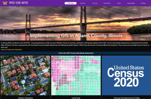
At WIU, the class is 407G – Social Applications of GIS, with the "G" meaning both graduate and undergraduate students can enroll. Sutton said he expected six students to enroll in the course, but he ended up with 26. He created teams for the students of the topics impacting the study, including housing, land use and transit, with students communicating with the relevant offices in Adams County.
"We created a public Web page to consolidate the teams' work," said Sutton. "They looked at the needs assessment by category, such as determining the housing situation, checking address data with the assessor's office and whether it was owner occupied, the age of the structure and building footprints."
One of the WIU students working on the project was junior Bradley Mercer, a GIS major, emergency management minor, from Cuba, IL, who has taken part is several hands-on GIS projects during his time at Western, including data collection on a lead pipe project in Silvis, IL. Mercer said the Quincy project gave him a chance to learn and use some additional web applications, as well as giving him a minor leadership goal.
WIU graduate student Marcus Baptiste, a GIS and Geoenvironmental major, from Grenada, said he learned a lot about new software and data extraction through the project.
"I learned 3D mapping from scratch," Baptiste said. "We also gathered information from the other groups in the class."
The final report included 3D mapping of each building in Quincy, as well as a digital map of transit routes in the community. Students also built the maps they used, some specifically for Quincy and others within the borders of Adams County.
Strong said she was impressed with the enthusiasm of the students, many who are nearing their end of their academic careers in degree programs such as community development and GIS.
"I would meet with all of them over Zoom to answer questions," she said. "The students took the idea of a community needs assessment and ran with it. The tools they brought led to success; it connected the dots. We were lucky to have that relationship."
One of the stakeholders in the needs assessment process was the city of Quincy. City Director of Planning and Development Chuck Bevelheimer, and Community Development Planner Jason Parrott participated with the students in the housing section of the needs assessment, in coordination with the Adams County Health Department.
"Maggie connected the GIS program and working on using the skills of students to get a better idea," said Bevelheimer. "It is awesome to look at the intricate, specific areas of the demographics of Quincy. We are still wrapping our hands around the data."
Parrott said they will eventually present the website and its data to the Quincy City Council.
"There is a large amount of information and we need to determine the best use for it," said Parrott.
Wingerter said the United Way's needs assessment wrapped up with three biggest community needs being determined as housing, poverty and behavioral health. He called the input of the GIS students a "perfect fit" with the assessment's data collection process.
"We learned a lot and we are excited about what the next semesters could bring," Wingerter said. "We would like to see them come to Quincy and expand the assessment to Adams County and to do field work on the ground. This work enriched what we were doing and it brought a piece to the table I may not have thought of."
Sutton said the work the class completed has been well received and there are discussions about continuing the class with other communities.
"This allowed our students to have real world experiences using GIS," said Sutton. "This type of work is one of the reasons WIU set the GIS Center up 20 years ago. This class has a service learning structure so students can learn the shortcomings of the data; what's not there. We wanted the students to have this type of experience for their portfolios. It showed them how to build the maps so the community can get what they want from the data."
The live website of the work completed by the students is available at tinyurl.com/WIUGIS4072022.
Posted By: Jodi Pospeschil (JK-Pospeschil@wiu.edu)
Office of University Communications & Marketing
Connect with us: